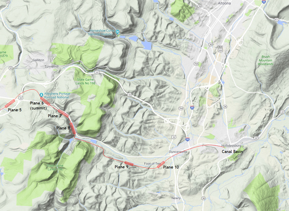
The Allegheny Front at Hollidaysburg
The escarpment is clearly visible in this view from Google Maps. On it, I have drawn the route of the Allegheny Portage Railroad from the canal basin at Hollidaysburg in the east to the summit at Plane 6, where the Park Service has its visitor center.
We, of course, have the advantage of this cool terrain map. The surveyors in 1826 did not. This entire area was largely forested, with few inhabitants. How many valleys full of poison ivy and rattlesnakes did they have to clamber up before they found the best route?
I'm guessing that this was their thinking:
- The starting point must be Hollidaysburg because that's where a canal along the Juniata River first enters this valley (alongside what is now U.S. 22). No other sizable watercourse in Pennsylvania gets this close to the Allegheny Front.
- The escarpments are too steep even for an inclined-plane railway, so they had to pick a valley.
- The northern valley (Horseshoe Curve) is too far north and leads to a pass that's 2,400'. The other two valleys top out at about 2,300'. The one they chose is closer to the canals in both Hollidaysburg in the east and Johnstown in the west.
We first flew this route, and then drove it by car.