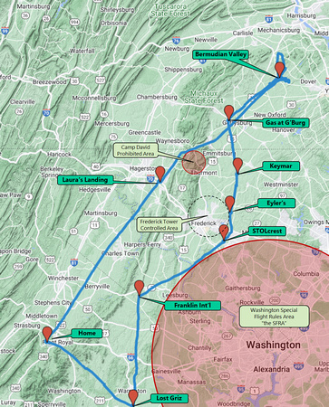
This little overnight trip involved SO many people and details. Honestly, it's what makes the sport fun. You can also see this map interactively in:
-
Google Maps for the actual track flown as shown here.
- The
aeronautical charts for the flight plan.
Going North. I began the trip at the lower left at the Front Royal airport where I hangar my trike.
The big obstacle between Front Royal and Bermudian Valley is the Catoctin Mountains. I won't be flying over those big green patches. Instead, I'll either fly around the Catoctins or cross them at their waist, as you see here.
Returning South. I needed to buy gas somewhere enroute, and the Gettysburg Airport was the most convenient place. After that, my destination was the Lost Griz Aerodrome where I was to lead the monthly meeting of
Flying Club 1 at 11am that morning. Along the way, I'd stop at a string of grass fields that I'd always wanted to visit.
My route threads between various restricted areas. The big pink controlled area around Washington is a no-go for me since I don't have the necessary transponder radio. I chose to avoid the "Class D" airspace around the Frederick Airport just to make the route more challenging. They would have cheerfully let me fly through. And, of course, both legs avoid the prohibited airspace around Camp David.